Little San Bernardino Mountains
Fun Valley, Riverside County, California
Chef Emile's Little San Bernardino Mountains Trail Log
December 26, 2006 Click here for Page One of the Hike!
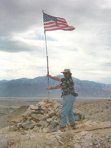
I Made It !!!
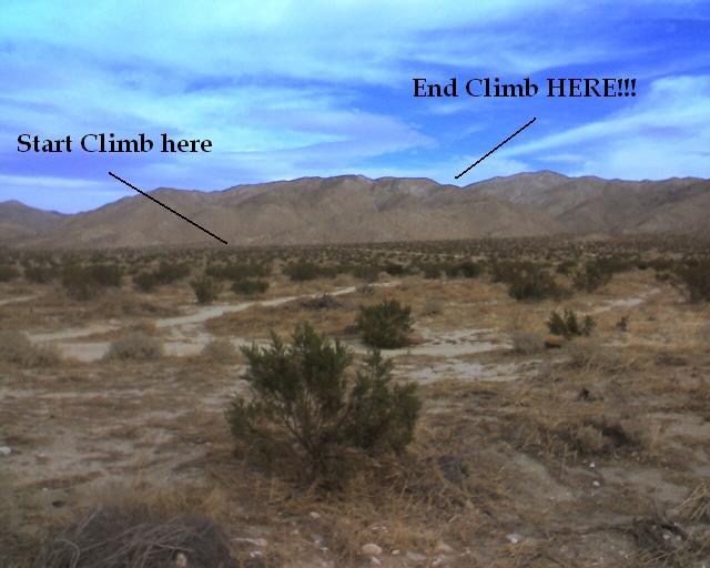
We started from where I took the pic, then hiked a mile
through the desert, then up the Little San Bernardino Mountain Ridge and made it
to the top!!
See
MAP (thanks, Florian!) The Fun Valley desert floor can be seen and Mt. San Jacinto is
almost due South. We took some time to rest at the summit
and to eat lunch. Marc and Sharon like to eat crackers, smoked oysters and
sardines on a hike!
 Go
Figure!! Actually, they are not bad, but I found that after lunch each day, we
were all burping!! I have got to figure out a better packed lunch!!
Go
Figure!! Actually, they are not bad, but I found that after lunch each day, we
were all burping!! I have got to figure out a better packed lunch!!
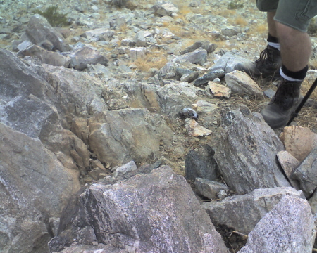
In the flag rock pile is a "Cache Box", my first experience
with one! They are ammo boxes that have "things" left by other hikers in them.
This one only had two trail sign in books and a pen. We leafed through the
spiral bound one, and as I remember it dated back to 1999, Cool!! Someone signed
the log the day before us on Christmas Day 2006. Why would someone want to hike
on Christmas Day is beside me, but there it was!! ( I wanta do Gumbo, Crawfish
Etouffee, and Jambalaya on Christmas!!)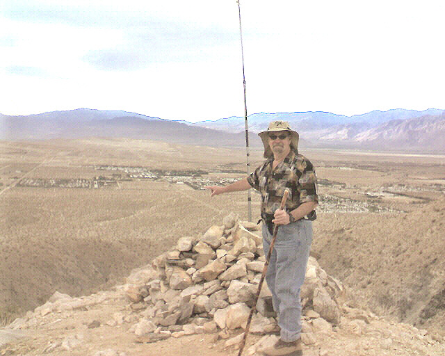
We were now about 1,100 feet vertically and about 3 miles
horizontally above the desert floor from where we started. I am pointing to the
south about to where my car is parked. Now that is cool!
 The
next pic is looking out across the desert, towards Palm Springs, Cathedral City
and Mt. San Jacinto. At the base of Mt. San Jacinto is
Tahquitz Canyon, where a couple of days
earlier we had hiked that trail. (OH, and I played golf at Mesquite Golf
Corse!!, I guess that shouldn't be in a Trail Log)
The
next pic is looking out across the desert, towards Palm Springs, Cathedral City
and Mt. San Jacinto. At the base of Mt. San Jacinto is
Tahquitz Canyon, where a couple of days
earlier we had hiked that trail. (OH, and I played golf at Mesquite Golf
Corse!!, I guess that shouldn't be in a Trail Log)
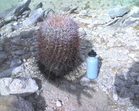
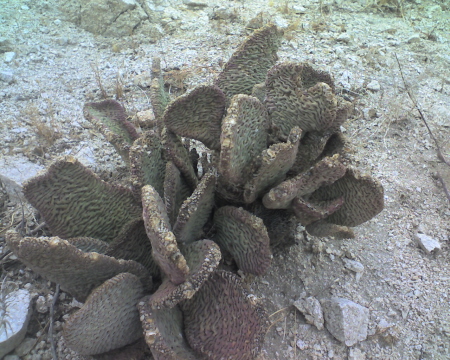 I
have found that I tend to see more when going downhill. This cactus is
like the pear cactuses that I saw in Texas. But it doesn't have the long spines,
and it is a little pinkish in color. I didn't touch it, so I don't know if the
small spines are sharp.
I
have found that I tend to see more when going downhill. This cactus is
like the pear cactuses that I saw in Texas. But it doesn't have the long spines,
and it is a little pinkish in color. I didn't touch it, so I don't know if the
small spines are sharp.
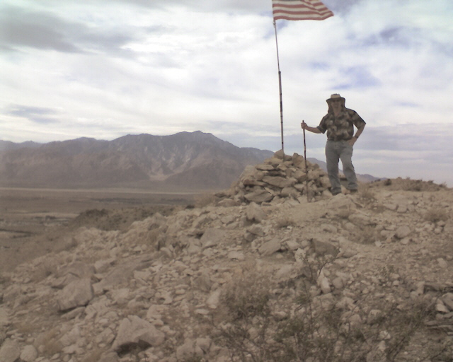
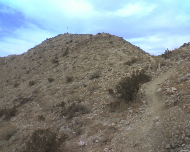 I
had to take one last look up and this is a shot from about 150 feet below the
summit. NOW, I can see the flag!! If you look to the right side of the pic you
can see the ridge trail that leads up to the summit. From about the same
position I took this pic of Marc and Sharon, it again is a good pic of the trail
that runs along the mountain's ridge. But it is difficult to get a perspective
as to how steep the drop-off is on either side of the trail and how far down the
valley floor is.
I
had to take one last look up and this is a shot from about 150 feet below the
summit. NOW, I can see the flag!! If you look to the right side of the pic you
can see the ridge trail that leads up to the summit. From about the same
position I took this pic of Marc and Sharon, it again is a good pic of the trail
that runs along the mountain's ridge. But it is difficult to get a perspective
as to how steep the drop-off is on either side of the trail and how far down the
valley floor is.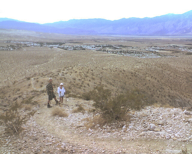 They were well below me, and only about 60 feet in distance, so as I have said
before, the grade is about 1/5. Plenty steep for me!
They were well below me, and only about 60 feet in distance, so as I have said
before, the grade is about 1/5. Plenty steep for me!
 Well,
just when you think you have seen everything, we stopped at one of the highest
and largest stone piles. There were plenty signs of bird droppings, so we
climbed around the pile and found this. I think it is a bobcat skull!
Cool!
Well,
just when you think you have seen everything, we stopped at one of the highest
and largest stone piles. There were plenty signs of bird droppings, so we
climbed around the pile and found this. I think it is a bobcat skull!
Cool!
 We
hiked down the ridge of the mountain, then decided to veer somewhat off course.
Rather than taking the ridge back all the way back to the desert floor, we
dropped down to a canyon that was to our right (west northwest) it was a wash that had
been explored by many of a 4 wheeler. The Fishhook Cactus on the left is a good
example of one that is somewhat large and healthy. However we came across the
one of the right, it was the largest that we had seen and only the shell had
remained! You can see right through it! You are looking down the barrel of the
cactus, almost 3 feet in depth. WOW, way Cool. IF you look to the left top
of the pic, you can see Sharon's legs as a perspective!
We
hiked down the ridge of the mountain, then decided to veer somewhat off course.
Rather than taking the ridge back all the way back to the desert floor, we
dropped down to a canyon that was to our right (west northwest) it was a wash that had
been explored by many of a 4 wheeler. The Fishhook Cactus on the left is a good
example of one that is somewhat large and healthy. However we came across the
one of the right, it was the largest that we had seen and only the shell had
remained! You can see right through it! You are looking down the barrel of the
cactus, almost 3 feet in depth. WOW, way Cool. IF you look to the left top
of the pic, you can see Sharon's legs as a perspective!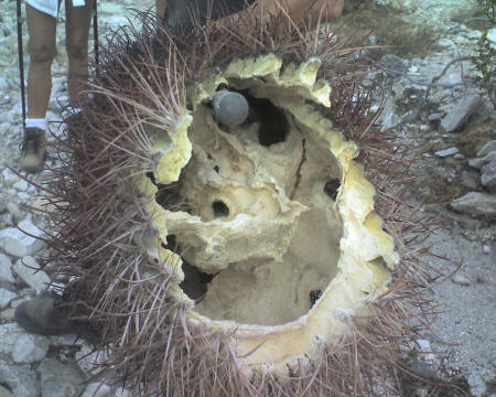
As we returned to the car walking the desert floor, I saw two jack rabbits! Wish I had had my 12 gauge! Just Kidding!
All in All it was a great hike! We had hiked about 6-7 miles and climbed vertically over 1,100 feet. I would rate the hike as moderate to strenuous. As for solitude, we only ran into one other group (3 people) and that was at the beginning of the ridge climb. If another group was near, we certainly would have seen them. The temperature was in the mid 60's, with a nice breeze, and some cloud cover. Check out the dramatic sky pics. This was my best hike so far!
Contact us for further details....notactive@customcatering.net
![]() to
Home Cookin' Page
OR
to
Home Cookin' Page
OR
![]() to Hiking Trail Log Page
to Hiking Trail Log Page![]()
Chef Emile L. Stieffel, Aurora Catering, Inc. email
address: notactive@customcatering.net
4016 Red Cypress Dr., Harvey, LA 70058 Phone (504)
-329-1344
Copyright © 1995 - 2007 [Aurora Catering, Inc.]. All
rights reserved.
Revised: December 20, 2011.